SPECIAL COVERAGE FOR THE NEW DAY AND THE FIRST TIME
Maria, a name that we will not forget:
September 20. 6:15 am It is the official time when Hurricane Maria, category 4 on the Saffir-Simpson scale, enters through Yabucoa and hits Puerto Rico. It crosses the entire island with sustained winds of 155 miles per hour that start, wallow and bite everything in its path.
The hurricane brings with it torrential rains that discharge on the ground up to 40 inches of water. The Grande de Loíza, Grande de Manatí and Grande de Arecibo rivers, as well as La Plata, between Comerío and Bayamón; Cibuco in Corozal; Holy Spirit in Rio Grande; El Guayama, El Piedras and Puerto Nuevo overflow and cause floods in almost 78 municipalities, causing terror, anguish and devastation.
The brutal winds and their gusts of up to 200 miles per hour swallow trees, bend traffic lights, fracture towers of light, remove roofs, what they find. María is a glass crushing machine. Shake the palms as if they were toys. Thousands break. Raise a furious sea with waves up to 25 feet high. You eat the beach and throw tons of sand on the most touristy streets of the island.
https://www.elnuevodia.com/videos/asisevivioelhuracanmariaenpuertorico-video-243366/
María’s anger does not rest on her way around the island. Diagonally, it hoists its hurricane winds on Maunabo, San Lorenzo, Caguas, Cidra, Aguas Buenas, Comerío, Naranjito, Corozal, Vega Alta and Vega Baja. He is angry with Manatí, Barceloneta and Florida. Squeeze Arecibo and slam the door between Hatillo and Camuy.
El Yunque, the only rain forest in the US National Parks system , and its thousands of native plants, including 88 considered rare and 23 unique, surrender to the onslaught of Mary.
The same happens with the Botanical Garden of Caguas, one of the most beautiful in the Caribbean. It is scorched earth. Nothing remains.
At 9 am it sweeps with San Juan, the capital. The historic center is desolate . The catastrophe accelerates. Hardly 14 days have passed since hurricane Irma, of category 5, hit Isla del Encanto. Paradise becomes hell. Governor Ricardo Rosselló had already warned: “It may be the worst atmospheric event in a century in Puerto Rico.” Is right.
In La Perla, the most famous community on the island outside, the roofs collapse. The houses give way.
That happened to the house of Luis Santiago, one of the residents of the base of the community, located on the sea. The before and after of your house is impressive.
“The step was too devastating. The house left. It is no longer useful, “says Luis.
In the northeast, the Fajardo river has left its channel and is about to flood the urban area and the mayor’s office. In Marina Puerto del Rey, the boats are left spinning; some, totally sunken. The mayor, Aníbal Meléndez, would declare later: “I had never seen my city so shattered”.

In Morovis and Orocovis , on the center of the island, the neighbors who have taken refuge in cement houses see how their own houses, made of wood, are removed from the hillsides by the jaws of Mary. In the Mountain , one of the regions most affected by the hurricane, the landslides swallow entire neighborhoods.

The chaos is total. In less than 8 hours, Maria has caused damages never seen by Puerto Ricans in the last 80 years. The despair among the people is absolute.
At 2 pm, an Air Force hurricane fighter plane captures María galloping off Puerto Rican soil to the Dominican Republic. But the tail of their winds are still felt for hours as a whip over Puerto Rico.
The hurricane leaves 100% of the island in the dark. 60% of the population does not have drinking water. The 78 municipalities remain incommunicado, with 92.7% of the telecommunications towers fallen. There is hardly internet in some areas of the metro air. There is no television, nor do cell phones work. Only one radio, Wapa, remains standing next to El Nuevo Día and Primera Hora. They are the only three media that report what happens with a national scope.
 Electricity towers of Barceloneta, bent by María.
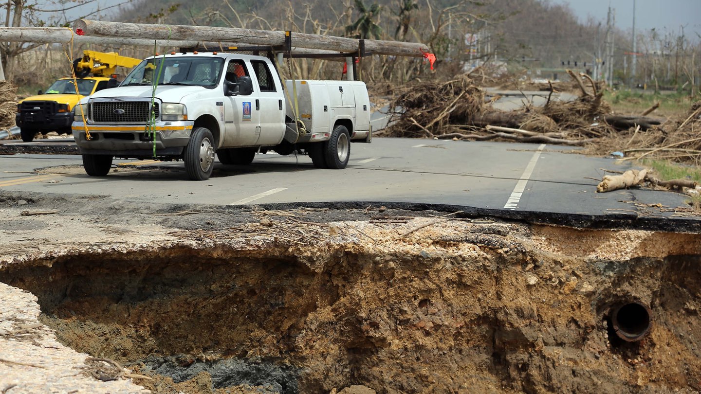
In each municipality the images are repeated again and again. Houses demolished, structures finished. Collapsed bridges; others, waterlogged; torn roads and open entrails. Arteries such as PR-111, between Moca and San Sebastián, yield to the weight of water and winds. Maria cracks the earth.
 The old bridge of La Virgencita on highway 2, at the entrance to Toa Alta.
The helicopters begin to fly over the neighborhoods. Puerto Rico has changed forever. It has another geography. The vegetation of forests like those of Utuado, Adjuntas and Jayuya loses its exuberant green, its majestic foliage. It seems burned by fire. According to the Department of Natural and Environmental Resources, 98% of adult trees are broken , crushed, obstructed routes and roads. The sea lost its turquoise. It looks like a river. Dark. Muddy. The sky, gray, continues to bring water. La Guancha, in Ponce, is the postcard of the day.
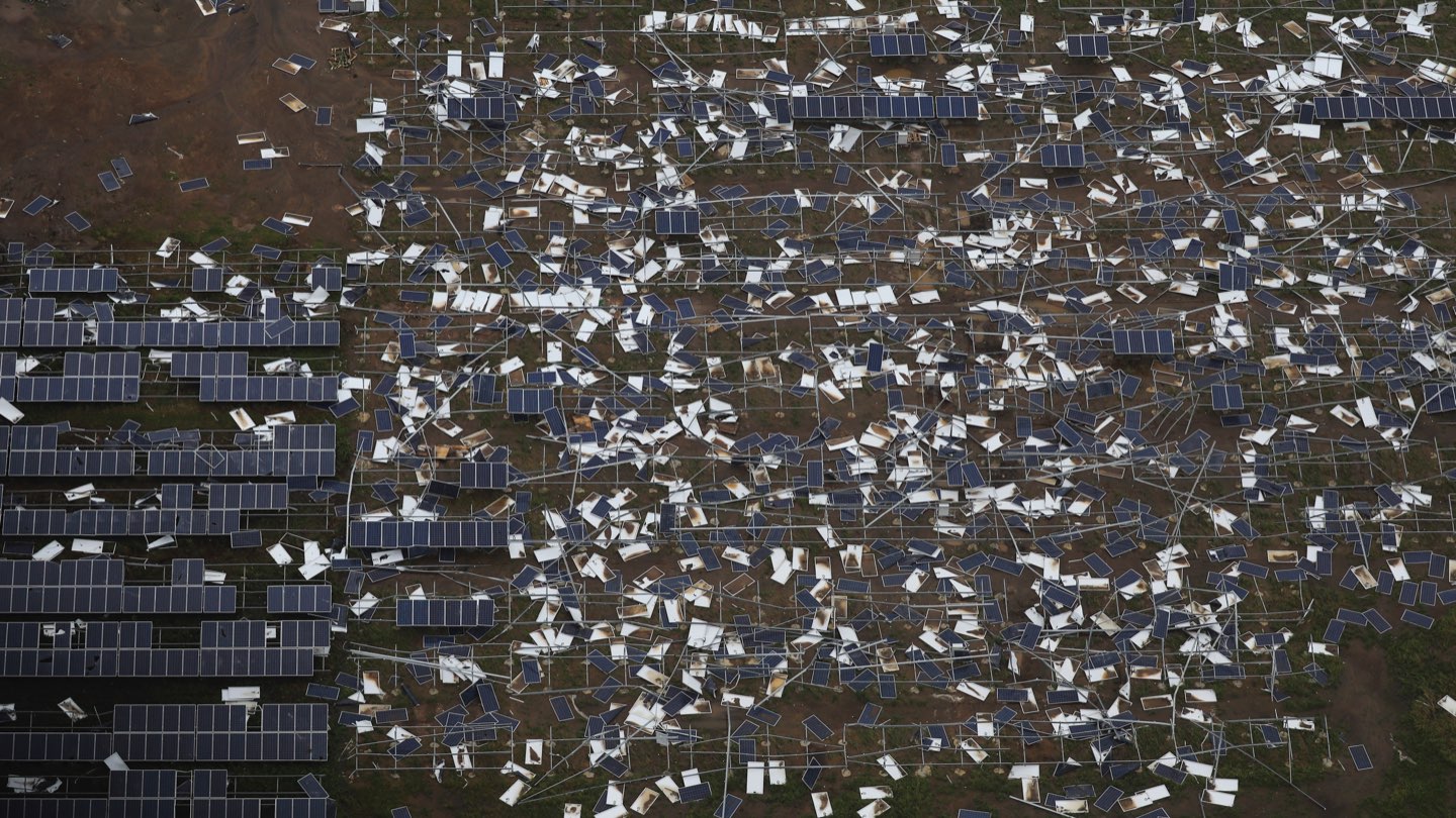
The solar farms of Humacao have been uprooted. From the air they look like loose, scattered pieces of paper. The 13 windmills of Naguado, installed in 2012 as a source of renewable energy, have been destroyed.
 The solar farms of Humacao, devastated by the hurricane.
Most hospitals on the island are without electricity. The next day, only seven of them can be kept running thanks to generators.
In the Levittown neighborhood, in Toa Baja, the water almost reaches the second floor of the houses. Evacuation and rescues are made of film. People literally have water around their necks. The authorities arrive in boats and boats to save the neighbors. They rescue 2,000 people at night .
The flow of the Bayamón and La Plata rivers overflows due to the Marian rains, leaving the region unrecognizable.

